
See the problem? The pin is in Sutton Coldfield, not Birmingham.
Mapping locations is a revealing technique for family and local history when the source contains spatial information. The 1939 Register contains 3 pieces of location information for each household:
- Borough or district. Counties were divided into four types of units, County borough (C.B), Municipal Borough (M.B.), Urban district (U.D.) and Rural district (R.D.). These units are listed in Understanding 1939 Registration Districts.
- Enumeration district. Boroughs and districts were divided into manageable areas for an enumerator to cover. They are denoted by the E.D. letter code. The One Place Studies blog published a helpful explanation of the 1939 enumeration districts and provide a list of these administrative units.
- Street address. No explanation needed.
 |
| Extract of 1939 Register with location information highlighted |
My grandparents lived in Stechford which was in the Birmingham County Borough. A Vision of Britain through Time is a comprehensive resource for jurisdictions in the UK. Sutton Coldfield was a Municipal Borough until it was merged with Birmingham in the 1974 re-organisation of local government. In 1939 the boundary of Birmingham County Borough was:
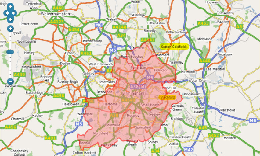 |
| Birmingham County Borough, with Sutton Coldfield and Stechford highlighted. Source: A Vision of Britain. |
Sadly smaller units like enumeration district QBEZ are not mapped in A Vision of Britain. Census enumerators books included a place to enter as description of the area covered, but I don't know if 1939 Register booklets did. Browsing the 23 images in the district reveals that only pages with personal entries have been published, so the context of the enumerator's work is missing. From the street addresses, it is possible to gain an insight of the area covered. Seven roads are named: Lyndon Road, Manor Road, Church Road, Station Road, Rosemary Road, and Yardley Fields Road.
All of the roads in enumeration district QBEZ are incorrectly scattered around Sutton Coldfield on Findmypast's maps. Here is a Google maps comparison of the real locations and Findmypast's locations:
 |
| Enumeration district QBEZ. Roads denoted by lines are actual locations, those denoted by pins are the 1939 Regsiter locations |
A road is a linear feature, so is better represented by a line than a point. Road names like Manor, Station, and Church are common. There are even several Lyndon Roads. These roads have been matched with other roads of the same name. Matching locations using a gazetteer, a geographical index of place names with co-ordinates or grid references, is fraught with difficulty. Red House, Rosemary and Yardley Fields roads were all pinned to the same spot as the incorrect Manor Road pin. It is likely that the more uncommon road names could not be matched, so were assigned to a pin thought to be in the enumeration district.
Findmypast's pins mislead even when correctly placed. A point or pin suggests accuracy, so one might expect it to identify a house. An jurisdictional area like an enumeration district or borough is best represented by a polygon, a shape which denotes the boundary of the feature.
Mapping technology is now widely and freely available. Findmypast used open source mapping software, Leaflet, to present the maps, delivering a smooth user experience. That was a smart move. Using the digitised historical maps from the National Library of Scotland and modern OpenStreetMap was another smart move. All of that came free.
It is clear that the jurisdictional boundaries from A Vision of Britain weren't used. Adding that data layer could have unleashed the power of spatial queries, eliminating the type of errors discussed here. The data seems to be available only for academic use, but the website was built over a decade ago, so would greatly benefit from serious investment. Investing in the development and expansion of A Vision of Britain would be, well visionary.
Great post Sue. It's obviously a serious issue for that locality, and you have to wonder how many others are incorrect for similar reasons. Am I right in thinking that TNA did the map associations, and not FMP? Have you approached TNA over the issues?
ReplyDeleteVery helpful, lots of good points, thanks, Sue!
ReplyDelete